Unlock the Power of Location Intelligence
GIS MApping & Cartography
We create accurate, clear, and visually compelling maps that help you understand your data, communicate insights, and support better decisions across your organization.
Transform Your Data Into Clear, Meaningful Maps
GIS Mapping & Cartography turns complex information into easy-to-understand visuals. We design professional maps that reveal spatial patterns, highlight key insights, and present your data with clarity. Whether you need maps for reporting, planning, operations, or public communication, we create custom GIS outputs that support smart decision-making across any industry.
What we Offer:
We deliver high-quality GIS maps, custom basemaps, and cartographic products optimized for planning, analysis, public communication, and reporting. Using reliable GIS data and clear symbology, we produce maps that communicate information effectively at any scale. Our mapping solutions support operational workflows, strategic planning, and data-driven decisions across all sectors.
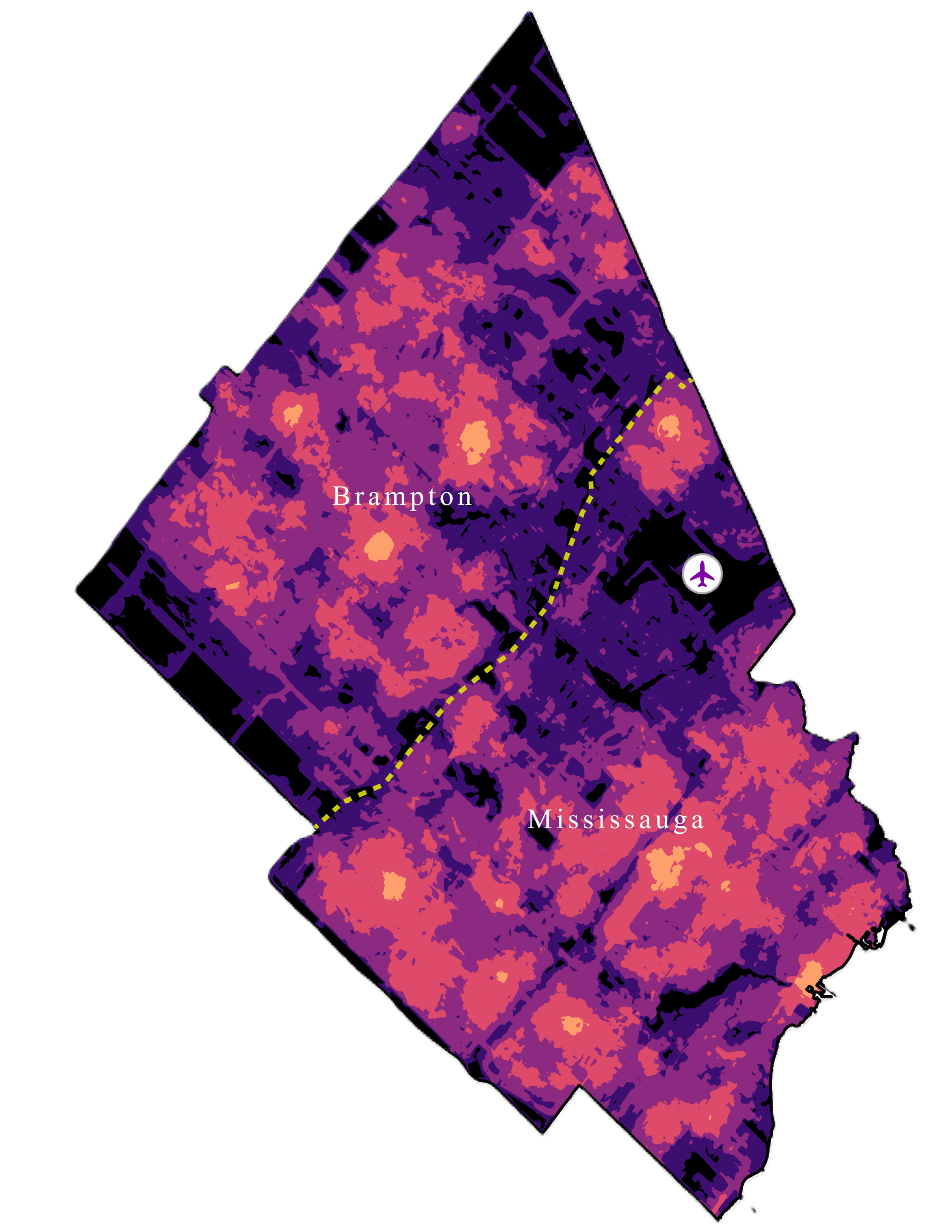
Custom Thematic Mapping
We create thematic maps that highlight trends, patterns, and spatial relationships within your data. Whether you need demographic analysis, risk identification, environmental mapping, or coverage comparison, our thematic maps make your insights clear and easy to understand. These maps support planning, communication, and data-driven decisions across any industry.
Multi-Scale Mapping (Local to Regional)
We design accurate GIS maps at any scale—from detailed site plans to regional or municipal overviews. Each map is optimized for clarity, with symbols, labels, and layers that remain readable at the intended zoom level. Multi-scale mapping supports strategic planning, operational management, and reporting for organizations of all sizes.
Interactive Web Maps
We build user-friendly interactive web maps that allow your team to explore, filter, and analyze spatial data in real time. These maps are ideal for ArcGIS Online, dashboards, internal operations, and public communication. Interactive mapping improves collaboration, transparency, and decision-making across departments and projects.
Printable & Export-Ready Maps
We design high-quality printable maps for reports, presentations, and stakeholder communication. Each map includes professional cartographic elements such as legends, titles, labels, scale bars, and branding. Our export-ready maps are ideal for proposals, planning documents, regulatory submissions, and public-facing materials.
Key BEnefits:
Our GIS Mapping & Cartography services deliver accurate, professional visuals that make complex information easy to understand and use for planning, communication, and decision-making.
Clear and professional map design
Accurate, GIS-ready spatial data
Consistent styling across all maps
Better communication with stakeholders
Improved analysis and planning workflows
Maps tailored to your industry and goals
Industries We Support
Ventro Analytics
Transforming complex data into clear maps, dashboards, and digital twins.
Quick Links
Home
Solutions
Contact Us
About Us
Solutions
Geospatial Analysis & Reporting
Custom Applications
Drone Mapping & Remote Sensing
Indoors GIS & GeoBIM
Mapping and Cartography